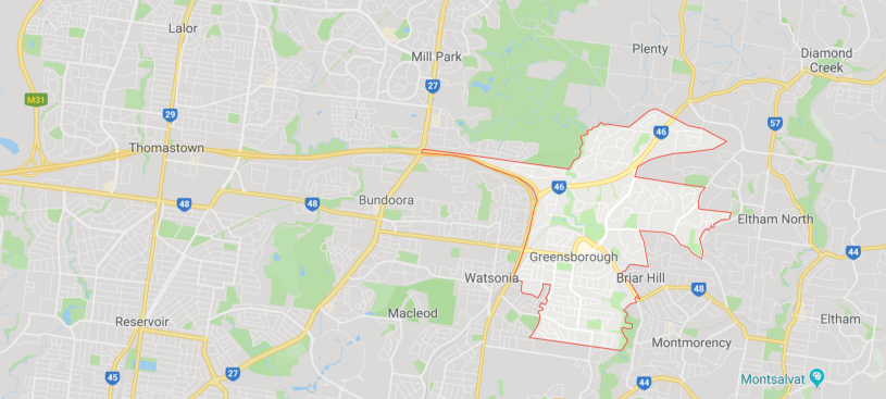
The outline of Greensborough’s border has been spectacularly accused of intimidating Thomastown and surrounding areas, thanks to an odd town planning quirk. It turns out that Greensborough curiously extends all the way to Plenty Road via a narrow strip on earth that is essentially just the Ring Road and its accompanying bike path. In isolation that doesn’t really mean much, but when combined with the rest of Greensy’s outline is makes for a shotgun-like outline that protrudes menacingly from a fancy-hatted looking soldier silhouette.
Local cartographers have reportedly been aware of the anomaly for many years now, but Thomastown resident Beryl Reynolds only made the discovery last week, quickly contacting The Watsonia Bugle in a desperate attempt to shine a light on the aggressive show of force from our neighbouring suburb. While Watsonia appears to fall safely in the shadow of the alleged weapon, Reynolds felt we were the right kind of news service to publicise the troubling issue, given our hard-earned reputation for investigative journalism and rampant enthusiasm for otherwise frivolous matters of suburban mapping.
In a wide-ranging interview, Reynolds said, “It’s all quite concerning, really. I mean, how long have they been pointing this menacing weapon straight at us? And why are they doing this? It’s all very troubling. I’ve actually been losing sleep over it, it’s a living nightmare.”
The supposed threatening gesture also comes as a shock to local suburban politics expert Helen Thomson, who had previously believed that most of Greensborough’s conflict resided within its own borders. Thomson said, “To be honest, I think it’s a bit of a mountain out of a molehill. Greensy tends to be too busy infighting to bother with picking fights with other suburbs. I think Beryl needs to just calm her farm.”
